Verified Details
This page shows the verified data. For all data click
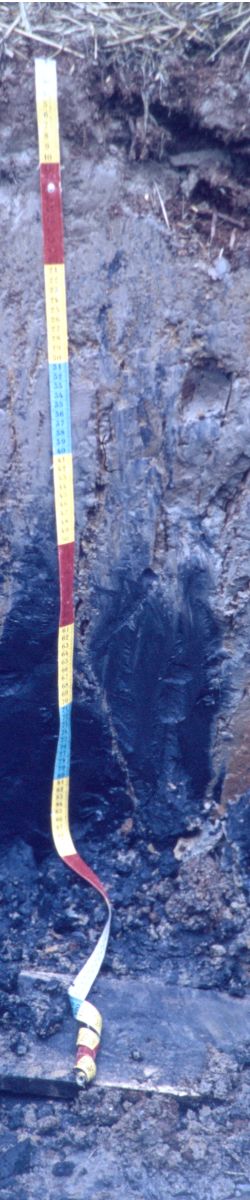
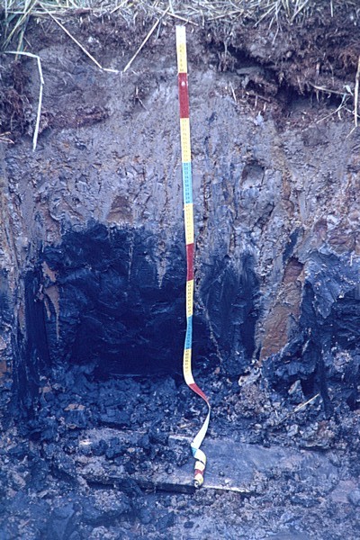
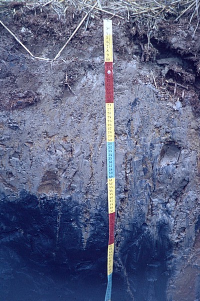
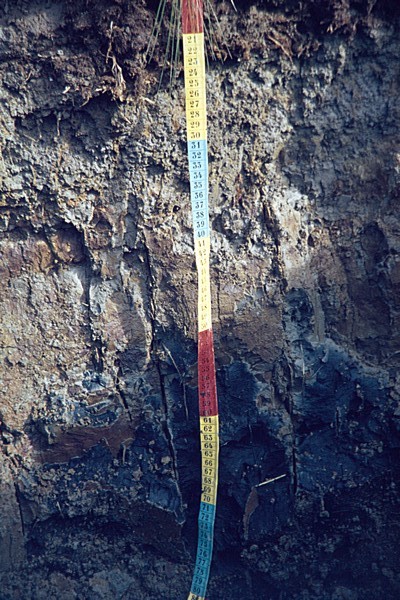
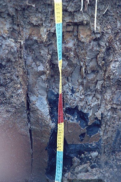
here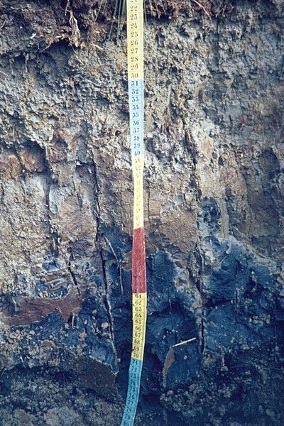 | Reference soil FI005: Fluvisol Description Land has been empoldered in 1958
|
Related images
(Click to view larger image) |  |  |  |  |  |
| FI-005-def:part of field picture | 197: | 198: | 199:Profile, detail 20-80 cm. | 200:Profile, diff. exp. | 201:Profile, detail 30-70 cm. |
General information
| Authors | Creutzberg D, M Sillanpää & J Sippola |
| Köppen | Dfc |
| Location | Near Maksamaa, about 25km ENE of Vaasa |
| Date | 1968-9-1 |
| Lat/Lon | 63.2333, 22.0833 |
Parent material
| Kind 1 (parent material) ; Parker (eds), 1984 | mixed lithology and composition |
| Mode of accumulation or deposition of parent material | marine sediments |
| Remarks on Parent Materials | silty-clayey marine deposits, partially riped |
| Texture of parent material | clayey |
| Texture of parent material (second entry) | clayey |
| Weathering Resistance | moderate |
| General characterization of the status of weathering of solid rock | slight |
Physiography
| Altitude | 0m |
| Physiographic Unit | polder |
| Physiographic position of the site | flat |
| Regional landform; McDonald, R.C., Isbell, R.F. et all, 1984; Australian soil and land survey Field Handbook, Inkata Press, Melbourne. | coastal plain |
| Slope | 0% |
| Topography; Guidelines for soil description - Fourth edition (FAO, Rome, 2006) | flat or almost flat |
Land use and vegetation
| Major crops | crops (unspecified) |
| Land improvements ; Guidelines for soil description - Fourth edition (FAO, Rome, 2006) | land improvements - not specified |
| Land use or vegetation in the immediate vicinity of the site | arable farming |
| Remarks on Land Use / Vegetation | LANDUSE: Land has been empoldered in 1958 |
Surface characteristics
| Evidence of alkali ; Soil Survey Manual USDA, 1951 | non-alkaline |
| Evidence of salt; Soil Survey Manual USDA, 1951 | slightly saline |
Hydrology and drainage
| Drainage class ; FAO (2006) - Guidelines for soil description | poor |
| Moist From - To | 0-80cm |
| Estimated permeability (class) of least permeable part of the profile | slow |
| Estimated run off (class) | very slow |
Other
| Description of a site | Land has been empoldered in 1958 |
Classification
WRB 2006
| Gleyic- Fluvisol (Thionic Dystric Clayic ) | |
| 30-45 cm | thionic horizon |
| 30-45 | sulphidic material |
WRB 1998
| Gleyi-Orthithionic- Fluvisol | |
| 0-20 cm | ochric horizon |
| 30-45 cm | sulfuric horizon |
| 20-70 | sulfidic material |
FAO 88
| Gleyi Thionic Fluvisol salic | |
| 0-20 cm | ochric A horizon |
| 30-45 cm | sulfuric horizon |
| - | sulfidic materials property |
FAO 74
| 0-20 cm | ochric A horizon |
| 30-45 cm | sulfuric horizon |
Other
| Classification information | Recently reclaimed soil in silty marine deposits |
local classification
| Classification information | Recently reclaimed soil in silty marine deposits |
| USDA-SCS (1975) | Fluvaquent aquic fine-silty mixed frigid |
Climate data
No climate data available for this sitePhysical characteristics
Particle size distribution
| Depth (cm) | Gravel % v/v | very coarse sand % w/w | coarse sand % w/w | medium sand % w/w | fine sand % w/w | very fine sand % w/w | Total sand % w/w | coarse silt % w/w | fine silt % w/w | Total silt % w/w | Clay % w/w |
| 0-20 | - | - | - | - | - | - | 1.8 | 29.9 | 36.5 | 66.4 | 31.8 |
| 20-30 | - | - | - | - | - | - | 0.7 | 26.9 | 32.7 | 59.6 | 39.7 |
| 30-45 | - | - | - | - | - | - | 1.2 | 5.7 | 52.1 | 57.8 | 41.0 |
| 50-70 | - | - | - | - | - | - | 4 | 12.5 | 46.1 | 58.6 | 37.4 |
Other physical data
| Depth (cm) | Bulk density kg/dm³ | Spec. Surf. Area m²/g | COLE cm/cm | Water disp. clay % | Clay % w/w |
| 0-20 | - | - | - | - | 31.8 |
| 20-30 | - | - | - | - | 39.7 |
| 30-45 | - | - | - | - | 41.0 |
| 50-70 | - | - | - | - | 37.4 |
Chemical characteristics
| Depth (cm) | pH H2O | pHKCl | EC 1: 2.5 dS/m | CaCO3 % w/w | C % w/w | N % | C / N | Exch. Acid cmol(c)/kg | Exch. Al cmol(c)/kg | Ca cmol(c)/kg | Mg cmol(c)/kg | K cmol(c)/kg | Na cmol(c)/kg | Sum Cations cmol(c)/kg |
| 0-20 | 4.2 | 4.0 | 1.21 | - | 3.29 | 0.31 | 11 | - | - | 5.2 | 3.7 | 0.1 | 0.2 | 9.2 |
| 20-30 | 3.2 | 3.1 | 1.24 | - | 2.54 | 0.27 | 9 | - | - | 1.6 | 2.1 | 0.0 | 0.2 | 3.9 |
| 30-45 | 3.0 | 2.9 | 2.56 | - | 2.81 | 0.30 | 9 | - | - | 2.6 | 1.2 | 0.0 | 0.2 | 4 |
| 50-70 | 3.4 | 3.3 | 4.90 | - | 3.31 | 0.34 | 10 | - | - | 5.2 | 5.5 | 0.2 | 1.1 | 12 |
| Depth (cm) | Base sat. % | CEC soil cmol(c)/kg | CEC clay cmol(c)/kg | CEC org cmol(c)/kg | ECEC cmol(c)/kg | Al sat. % | ESP % | Effective cation exchange capacity (ECEC) - ISRIC cmol(c)/kg |
| 0-20 | 34 | 27.2 | 49 | 11.5 | - | - | 1 | - |
| 20-30 | 15 | 26.1 | 43 | 8.9 | - | - | 1 | - |
| 30-45 | 13 | 30 | 49 | 9.8 | - | - | 1 | - |
| 50-70 | 39 | 30.5 | 51 | 11.6 | - | - | 4 | - |