Luvisols occur mainly in temperate regions, particularly in areas with a Mediterranean-type of climate.
Characteristics
Soils having an argic horizon (a subsurface horizon with a distinct higher clay content than the overlying horizon) with a cation exchange capacity equal to or more than 24 cmolc per kg clay throughout.
Reference soil BW006: Luvisols
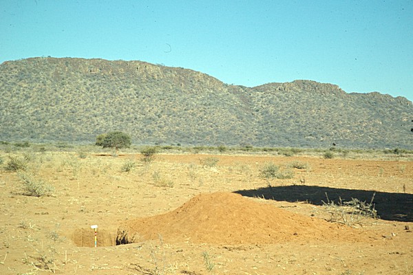
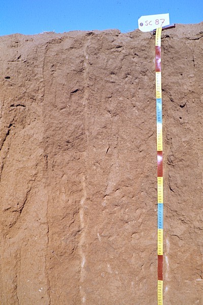
LOCATION: 3 km South of the road to Mahalapye GEOLOGY: Undifferentiated granitic rocks from the basement complex with subordinate occurrence of dolerite. ROCK OUTCROPS: Marutlwe hill (doleritic sill) 1 km to the South VEGETATION: Combreapiculatum, Acacia nigerescens (on abandoned field) Acacia tortilis and Dichrostachys cinerea. MORPHOLOGY: B3 Coarse fragments increasing with depth C Extremely hard mottled granite BRIEF PROFILE DESCRIPTION: A deep, well drained, reddish brown coarse sandy loam with gradual horizonation and weak to none structural development. The soil reaction is slightly acid throughout.
| Authors | Siderius W |
| Location | 8km SE of Shoshong and 3 km S of the road to Mahalapye |
| Köppen | BSh |
| Date | 1970-02-01 |
| Lat/Lon | -23.0667, 26.8000 |
BW006

| Kind 1 (parent material) ; Parker (eds), 1984 | igneous rock |
| Mode of accumulation or deposition of parent material | residual material |
| Remarks on Parent Materials | undifferentiated granitic rock of the Basement Complex (Precambrium) with subordinate occurence of dolerite; Marutwe hill (doleritic sill) occurs 1km to the south |
| Texture of parent material | loamy |
| Weathering Resistance | high |
| General characterization of the status of weathering of solid rock | highly |

| Physiographic Unit | gently sloping pediment |
| Regional landform; McDonald, R.C., Isbell, R.F. et all, 1984; Australian soil and land survey Field Handbook, Inkata Press, Melbourne. | pediplain |
| Topography; Guidelines for soil description - Fourth edition (FAO, Rome, 2006) | rolling |
| Slope | 0% |
| Altitude | 1131m |

| Kind of ground water table (USDA, 1979) | no groundwater table observed |
| Drainage class ; FAO (2006) - Guidelines for soil description | well |
| Dry From - To | 0-170cm |
| Flooding frequency (FAO, 1986) | never |

| Land use or vegetation in the immediate vicinity of the site | low level arable farming |
| Major crops | sorghum |
| Major vegetation type; Guidelines for soil description - Fourth edition (FAO, Rome, 2006) | semi-deciduous woodland |
| Land improvements ; Guidelines for soil description - Fourth edition (FAO, Rome, 2006) | land clearing |
| Remarks on Land Use / Vegetation | Savanna, Acacia Mixed Woodland with Combreapiculatum, A. nigerescens (on abandoned field), A. tortilis and Dichrostachys cinera |
| Status of vegetation; Guidelines for soil description - Fourth edition (FAO, Rome, 2006) | modified |

| Evidence of alkali ; Soil Survey Manual USDA, 1951 | non-alkaline |
| Rock outcrop class (FAO (2006) - Guidelines for soil description) | none |
| Evidence of salt; Soil Survey Manual USDA, 1951 | non-saline |
| Microrelief pattern | reticulate |
| Micro relief type: small-scale differences in relief in the direct vicinity of the site (FAO, 1986) | levees (artificial) |
| Surface stoniness class (FAO (2006) - Guidelines for soil description) | none |
| Surface cracking | no cracks observed |
WRB 2006
| Haplic Luvisols (Profondic Chromic ) |
| 33-122 | argic horizon |
WRB 1998
| Profondic Chromi Luvisols |
| 33-122 cm | argic horizon |
| 0-33 cm | ochric horizon |
FAO-UNESCO-ISRIC 1974
| Luvic Yermosols |
| 0-33 cm | ochric A horizon |
| 33-170 cm | argillic B horizon |
| 87-100 | plinthite horizon |
| 87-115 | hydromorphic horizon |

| USDA-NRCS (1999) | Psammentic Haplustalf ustic coarse-loamy siliceous hyperthermic |
| USDA-SCS (1975) | Psammentic Paleustalf ustic coarse-loamy siliceous hyperthermic |

| Description of a site | LOCATION: 3 km South of the road to Mahalapye GEOLOGY: Undifferentiated granitic rocks from the basement complex with subordinate occurrence of dolerite. ROCK OUTCROPS: Marutlwe hill (doleritic sill) 1 km to the South VEGETATION: Combreapiculatum, Acacia nigerescens (on abandoned field) Acacia tortilis and Dichrostachys cinerea. MORPHOLOGY: B3 Coarse fragments increasing with depth C Extremely hard mottled granite BRIEF PROFILE DESCRIPTION: A deep, well drained, reddish brown coarse sandy loam with gradual horizonation and weak to none structural development. The soil reaction is slightly acid throughout. |

| Ah 0-33 cm | reddish brown (5YR 4/3, moist) reddish brown (5YR 4/4, dry)coarse sand,structureless single grain to weak subangular blocky,SD loose (dry and moist) non sticky non plastic,common fine and few medium roots,few termite channels,non calcareous,gradual smooth boundary to, |
| Bt1 33-80 cm | yellowish red (5YR 4/6, moist) yellowish red (5YR 4/6, dry)loamy coarse sand,structureless single grain to weak subangular blocky,SD loose non sticky non plastic,common fine medium tubular pores,few fine and medium roots,non calcareous,gradual smooth boundary to, |
| Bt2 80-129 cm | dark reddish brown (2.5YR 3/4, moist) yellowish red (5YR 4/8, dry)coarse sandy loam,structureless massive to weak subangular blocky,slightly hard friable non sticky non plastic,common fine tubular pores,common fine and few medium roots,non calcareous,gradual smooth boundary to, |
| BC 129-170 cm | dark red (2.5YR 3/6, moist) yellowish red (5YR 5/6, dry)coarse sandy loam,structureless massive,slightly hard friable non sticky non plastic,common fine and medium tubular pores,few fine roots,few coarse gravel fragments,non calcareous,abrupt smooth boundary to, |
| C 170- cm | structureless massiveextremely hard,common mottles,non calcareous, |

| Depth (cm) | C % weight/weight | Ca cmol(c)/kg | CaCO3 % weight/weight | C / N unitless | EC 1: 2.5 mS/cm | Exch. Acid cmol(c)/kg | Exch. Al cmol(c)/kg | K cmol(c)/kg | Mg cmol(c)/kg | N % | Na cmol(c)/kg | pH H2O unitless | pHKCl unitless | Sum Cations cmol(c)/kg |
| 0-33 | 0.16 | 1.3 | - | 5 | 0.11 | - | - | 0.3 | 0.1 | 0.03 | 0.0 | 6.3 | 4.7 | 1.7 |
| 33-80 | 0.18 | 1.3 | - | 6 | 0.11 | - | - | 0.3 | 0.0 | 0.03 | 0.0 | 6.3 | 4.7 | 1.6 |
| 80-129 | 0.05 | 1.3 | - | - | 0.18 | - | - | 0.3 | 0.2 | - | 0.2 | 6.3 | 4.7 | 2 |
| 129-170 | 0.15 | 1.3 | - | - | 0.2 | - | - | 0.3 | 0.2 | - | 0.0 | 6.4 | 4.8 | 1.8 |
| Depth (cm) | Al sat. % | Base sat. % | CEC clay cmol(c)/kg | CEC org cmol(c)/kg | CEC soil cmol(c)/kg | ECEC cmol(c)/kg | ESP % |
| 0-33 | - | 44 | 52 | 0.6 | 3.9 | - | 0 |
| 33-80 | - | 36 | 36 | 0.6 | 4.4 | - | 0 |
| 80-129 | - | 42 | 28 | 0.2 | 4.8 | - | 4 |
| 129-170 | - | 38 | 29 | 0.5 | 4.8 | - | 0 |

Particle size distribution
| Depth (cm) | Clay % weight/weight | coarse sand % weight/weight | coarse silt % weight/weight | fine sand % weight/weight | fine silt % weight/weight | Gravel % volume/volume | medium sand % weight/weight | Total sand % weight/weight | Total silt % weight/weight | very coarse sand % weight/weight | very fine sand % weight/weight |
| 0-33 | 7.5 | - | 2.5 | - | 0.6 | 1 | - | 89.4 | 3.1 | - | - |
| 33-80 | 12.3 | - | 2.4 | - | 1.2 | 1 | - | 84.1 | 3.6 | - | - |
| 80-129 | 16.9 | - | 3.3 | - | 2.1 | 2 | - | 77.7 | 5.4 | - | - |
| 129-170 | 16.3 | - | 3.9 | - | 1.9 | 3 | - | 77.9 | 5.8 | - | - |
Other physical data
| Depth (cm) | Bulk density kg/dm³ | Clay % weight/weight | COLE cm/cm | Spec. Surf. Area m²/g | Water disp. clay % |
| 0-33 | - | 7.5 | - | - | 3.5 |
| 33-80 | - | 12.3 | - | - | 5.0 |
| 80-129 | - | 16.9 | - | - | 5.9 |
| 129-170 | - | 16.3 | - | - | 7.3 |

| Depth (cm) | Al2O3 % weight/weight | CaO % weight/weight | Fe2O3 % weight/weight | K2O % weight/weight | MgO % weight/weight | Na2O % weight/weight | SiO2 % weight/weight | TiO2 % weight/weight |
| 0-33 | 5.8 | 0.13 | 1.9 | 3.22 | 0.19 | - | 88.9 | 0.24 |
| 33-80 | 8.8 | 0.14 | 2.7 | 3.21 | 0.53 | - | 85.2 | 0.54 |
| 80-129 | 9.7 | 0.15 | 1.9 | 3.41 | 1.08 | - | 79.3 | 0.49 |
| 129-170 | 8.9 | 0.16 | 2.8 | 2.74 | 0.63 | - | 80.1 | 0.55 |
| Depth (cm) | Al2O3/Fe2O3 mol/mol | LOI % weight/weight | MnO2 % weight/weight | P2O5 % weight/weight | SiO2 / Al2O3 mol/mol | SiO2/Fe2O3 mol/mol | SiO2 / R mol/mol |
| 0-33 | 4.8 | 2.1 | 0.02 | 0.02 | 26 | 124.4 | 21.5 |
| 33-80 | 5.1 | 3.1 | 0.02 | 0.00 | 16.4 | 83.9 | 13.7 |
| 80-129 | 8 | 3.5 | 0.02 | 0.10 | 13.9 | 110.9 | 12.3 |
| 129-170 | 5 | 3.2 | 0.02 | 0.08 | 15.3 | 76 | 12.7 |


